


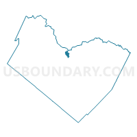
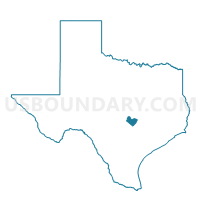
Voting District 0326, Travis County, Texas
About
Outline

Summary
| Unique Area Identifier | 677663 |
| Name | Voting District 0326 |
| County | Travis County |
| State | Texas |
| Area (square miles) | 1.96 |
| Land Area (square miles) | 1.96 |
| Water Area (square miles) | 0.00 |
| % of Land Area | 100.00 |
| % of Water Area | 0.00 |
| Latitude of the Internal Point | 30.41019050 |
| Longtitude of the Internal Point | -97.78171070 |
Maps

Graphs
Select a template below for downloading or customizing gragh for Voting District 0326, Travis County, Texas


Neighbors
Neighoring Voting District (by Name) Neighboring Voting District on the Map
- Voting District 0327, Travis County, TX
- Voting District 0331, Travis County, TX
- Voting District 0335, Travis County, TX
- Voting District 0336, Travis County, TX
- Voting District 0337, Travis County, TX
Top 10 Neighboring County Subdivision (by Population) Neighboring County Subdivision on the Map
Top 10 Neighboring Place (by Population) Neighboring Place on the Map
Top 10 Neighboring Unified School District (by Population) Neighboring Unified School District on the Map
- Austin Independent School District, TX (636,113)
- Round Rock Independent School District, TX (231,853)
Top 10 Neighboring State Legislative District Lower Chamber (by Population) Neighboring State Legislative District Lower Chamber on the Map
Top 10 Neighboring State Legislative District Upper Chamber (by Population) Neighboring State Legislative District Upper Chamber on the Map
Top 10 Neighboring 111th Congressional District (by Population) Neighboring 111th Congressional District on the Map
Top 10 Neighboring Census Tract (by Population) Neighboring Census Tract on the Map
- Census Tract 17.14, Travis County, TX (13,159)
- Census Tract 17.55, Travis County, TX (5,769)
- Census Tract 17.16, Travis County, TX (5,039)
- Census Tract 17.82, Travis County, TX (4,955)
- Census Tract 17.56, Travis County, TX (3,997)
- Census Tract 17.57, Travis County, TX (1,934)